Upper Dolpo Trek

30 Days

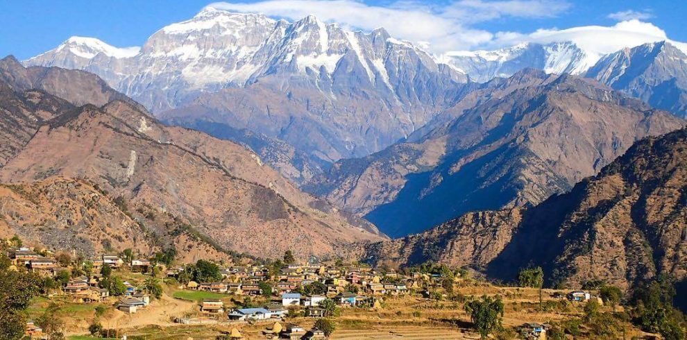
Upper Dolpo Trek is a less crowded trip in the rural part of Nepal, located in the middle point of the Tibetan land and the Dhaulagiri mountain range. Upper Dolpo as an isolated trekking destination of Nepal has got incredible Himalayan beauties, wonderful landscape and the cultural wilderness. The various high passes make this trek more challenging and adventurous. The trek is a trip in the hidden wonderland.

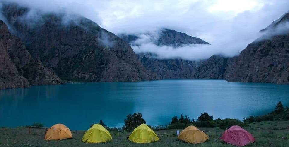
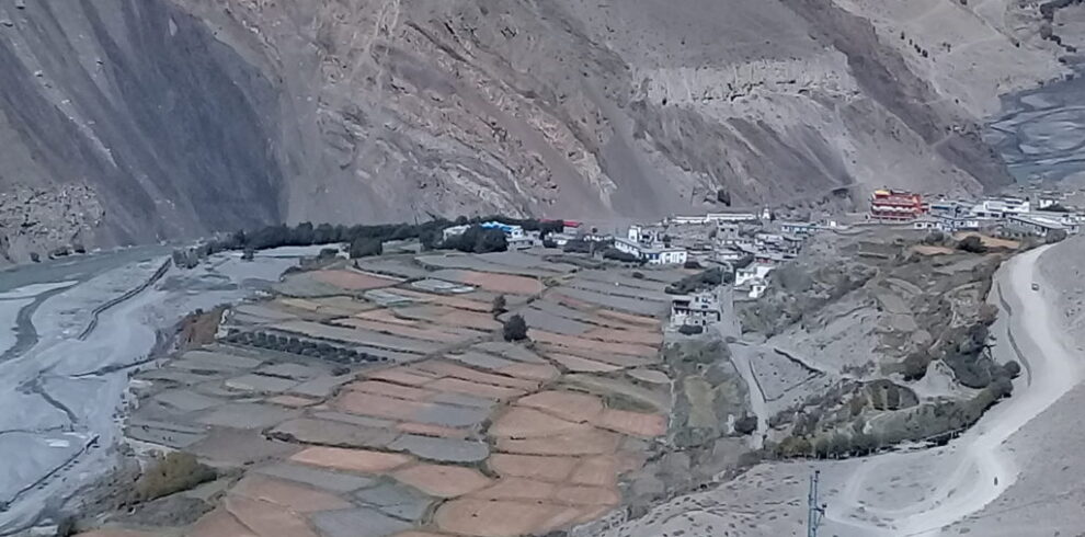
Trek to Upper Dolpo offers the remote picturesque sceneries and the natural diversities. The trek initiates from Juphal airport of Dolpo. The pristine Phoksundo Lake is the first attraction of the trekking, which represents the numerous beauties of the Dolpo region. It is also the deepest lake of Nepal. The treks to Upper Dolpo have the mesmerizing views of the hidden settlements of the Dolpali people, who have different accents and unique cultural form. The influence of the Tibetan Buddhism can be seen during the trekking. Shey Gompa and other numerous monasteries prove the cultural richness in the Upper Dolpo region. Various high passes, alpine meadows and the cascading waterfalls allure you to this hidden gem. Kang La pass (5151m), Saldang La Pass (4785m) and Jeng La Pass (4845m) are the thrilling high passes in the trip to Upper Dolpo. The innocent smiles of the local faces and their ethnic hospitality are wonderful.

Beautiful Lakes, Himalayan chain of the Dhaulagiri range, Buddhist monasteries and the wilderness of flora and fauna resemble the key features of trekking in Upper Dolpo. Good physical fitness and acclimatization are required for the Upper Dolpo trek. For more details, please contact Reliance Trekking for the detailed information about this trek.

       Highlights of Upper Dolpo Trek

  • Upper Dolpo Trek through parts of Nepal that very few trekkers ever see.
  • Phoksundo lake is Deep lake in Nepal 220m. Deep
  • Visit 800 years oldest Shey Gompa, Monasteries of the base of Crystal Mountain, immortalized in Peter Matthiessen’s
  • The Shey Phoksundo National Park, one of the highest animal concentration in the world.
  • Seen many wild animals like a Snow leopard, Mountain thar, Blue sheep etc.
  • Many High passes; Khang La, Saldang La, and others.
  • Desert and landscape and striking valleys as: Do, Saldang and Charka vot and Kagbeni
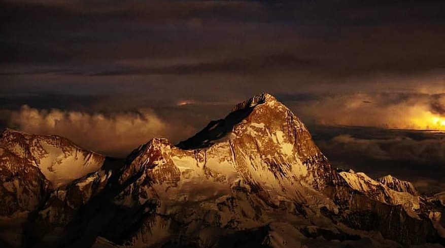
  • Views of Dhaulagiri, Mountain Putha, Nilgiri, Tilicho and Tibetan peaks


Itinerary

Day 1 :
Arrival in Kathmandu airport (1345meters).
Our representative will be receiving you at Tribhuvan International airport, Kathmandu and s/he will be transffered to hotel in our private tourist vehicle. O/N at Hotel on Kathmandu.(Breakfast included)
Day 2 :
Pre-trip Meeting and Kathmandu city sightseeing Tour.
For the meeting, please make sure you bring passport, three copies of passport-size photos, and a readable copy of your travel insurance policy. During this meeting, please clear the due balance, if any, and sign the legally binding trip form as well as the non-liability disclaimer. Please inform us in advance if you will be arriving late and therefore are unable to attend the pre-trip meeting. After the Pre-Trip meeting and breakfast, your sightseeing trip will start in the morning. Itinerary as Boudhnath Stupa, one of the biggest Buddhist shrines in the world, where observe Buddhist monks in prayer in the monasteries surrounding the stupa. After Boudhnath Stupa, Pashupatinath, the most famous Hindu temple in the country, located on the banks of the holy Bagmati River. Hindu holy men (sadhus) meditating, pilgrims bathing and occasionally funeral pyres burning on the ghats. Overnight Hotel. (Breakfast included)
Day 3 :
Flight from Kathmandu to Nepalgunj(400m)
Flight from Kathmandu to Nepalgunj .flight hour 40minute and O/N at Hotel on Nepalgunj. (Breakfast included)
Day 4 :
Flight from Nepalgunj to Juphal (2320m) and trek to Dunai (2855m)
In the morning after breakfast,flight takes 35 minutes morning flight to Juphal, which offers you to observe the high mountains such as Annapurna and Dhaulagiri summit. After landing from the flight, our first day’s adventure begins through the terraced fields to the Bheri River and the narrow ravine after 4 hours walking. Camping on Dunai.
Day 5 :
Trek from Dunai to Shyanta (2525m)
The trail to Shyanta goes beside the suli khola and passing through the Suli ghat villagecross the Shuli bridge and and continue walk forward to the Shyanta from the left of Shuli khola up to kageni village. here again cross the Suli river . walk 5 hours Campping on shyanta.
Day 6 :
Trek from Shyanta to Rechi (2940m)
Trek from Shyanta , follow the same river, walk from the right side of the river and crossing the village Chhekpa (2838 m) crossing the three bridges at same river Rechi 2940 meter can be reached.Walk 5 hours ,Campping on Rechi.
Day 7 :
Trek from Rechi to Phoksundo ( Ringmo gaon) (3725m)
Trek starts just cross the bridge moving ahead following the river again. The trail is no more up and down ,continue walk forward to Sanduwa where two rivers Pagma Khola and Phoksundo Khola meets together. From there crossing the river and goes besides the Phoksundo khola to it’s origin Phoksundo Lake, which is the major attraction of the trek walk 6 hour ,Camping on phoksundo(ringmo Gaon).
Day 8 :
Exploration and rest day at Phoksundo Lake (3733m)
This is one of the main lakes of Nepal, where the reflection of the Landscape on its clear blue sky water surface can be seen. This day will visit around the lake and explore around as well observe the beauty of She-Phoksundo national Park. And also visit to the monastery near to Phoksundo Lake Camping on phoksundo(ringmo Gaon).
Day 9 :
Trek from phoksundo (ringmo Gaon) to Chabluk Phu (3625m)
This day up head forward to the next camp following the trail, which goes from west bank the Lake Phoksundo. Initially it goes flat forward from the lake bank and the it gradually ascend up for half houra the descend down close to the bank of the lake again and continue heads forward through the Phoksungo khola. Walking through slightly up and down we get to the camp and we spend our night at Chablu Phu khola .walk 6 hour camping on chabluk phu which is grazing area.
Day 10 :
Trek from chabluk to Mandala (4625m)
This trek starts with a level walk to the northwest through scrub and briar changing to bright Autumn colors. Which is entering the real Dolpo, and to enter into this mystical land to cross the Ngongda La or Kang. The valley is magical as head north and pass a small campsite marked by a beautiful mani stone. Soon after the valley fills with open forest of birches and rose-buds, and then narrows. When turn right up the first small intersecting valley (it’s easy to miss the trail, so stay with the group) which follows a rocky river to our campsite. Finally, a few tough hours later, we reach our ‘high’ camp, which Mattheissen named Snowfields Camp.Camping on Snowfields Camp (Mandala).
Day 11 :
Trek from Mandala to Shey Gomba (4160m)
From Chabluk Phu camp, follow the trail which gradually ascend up to the hills to Nandalo (5110 m) then it goes down to the river and then it goes besides this river and crossing it twice we get to Shey Gomba. An old Bhuddist monastery where can observe the Buddhist old wall painting and the tradition pooja pray.Walk 5 hours and here is the pass on the way the journey is little bit difficult for this day.Camping on shey Gomba.
Day 12 :
Trek Shey Gomba to Namgung (4380m)
The trail parallel with the river leads from its left bank around two hours then is gradually goes upward to the high pass named Saldang (5010m) it is an incredible view point which is treated to magnificent panoramic views of the peaks surrounding Dolpo, with Mustang to the east, Tibet to the north, and Kanjiroba, Kagmara and Riu Dhukta, or the Crystal Mountain, to the West. From this pass the trail again goes downwards walk 6 hour camping on Namgung (4380 m).
Day 13 :
Trek from Namgung to Saldang (3980m)
A short but spectacular day along the high trail leading to Saldang, with large birds of prey and sometimes migrating Demoiselle Cranes soaring above and passing several doksas and villagers en route. After a few hours of easy contouring and a few climbs,crest a ridge topped with prayer flags and look down on Saldang below us and the crinkle of dun-colored mountains to the north, bordering on Tibet. You can see the route to the Panzang valley from the ridge, and can pick out much of our route after leaving Saldang. After more contouring and several steep, sandy descents,reach ‘Caravan Thinle’s’ typically Tibetan-style house at the northern end of the village, spectacularly set campsite is at the far southeast of this large village, so it will take us at least half an hour to wander through this fascinating and scenic Tibetan village, past mani walls and through kanes, down village lanes and around tilled barley fields.camping just above ochre Saldang Gompa, gold-gilded and sparkling in the mid-day sun. walk 6 hours O/N at tented camp on Saldang.
Day 14 :
Explore on Saldang Village
A free day in wonderful Saldang village, the largest village in the Nangkhang region of Dolpo with many exploration options. One is to make a loop through some of the villages north of Saldang, where the autumn harvest will be in full force. Follow the Nagon Khola north to Karang and Marang villages for a look into village life; Thinle will introduce us to his friends and relatives, and we might have the chance to visit a local house for some dried cheese (chhurpi) and salt-butter tea. Another option is to explore Saldang, as the maze of alleys that winds through the village is endlessly fascinating. Below us adjoining Saldang Gompa is the Amchi Hospital run by a localAamchi and his son. The Amchi is one of the stars of the movie ‘Himalaya’ and showed Kim the instrument that was used in the movie to burn Thinle’s chest when after the snow-storm. There is a great book on the making of Himalaya in the newer annex of the gompa above our campsite, worth a walk up. The amchi speaks a bit of English, his son more, and are fascinating to talk with. Thinle’s house is next door to campsite. O/N at tented camp Saldang.
Day 15 :
Trek from Saldang to Khomagaon (4100m)
Last year’s exploratory section of the trek began here, and we’ve kept the route this year as it was truly amazing: remote, stunningly beautiful, purely Tibetan and some of the best trekking in the entire Himalaya. Heading down past Saldang Gompa along the route to Dho we continue along the Nagon Khola though Sugugaon, a bustling, white-washed village and past long mani walls, painted chortens and old gompas perched high up along the mountainsides. At Chagaon, we cross the Nagon Khola on a small bridge and head straight up the dusty ridge on a steep, rocky switch-backing trail for an hour. Dropping down to a dry, black riverbed,to climb again to a grassy plateau where we’ll stop for a much -needed lunch break. A further fifteen minutes brings us to the Khoma La (4565 meters), from where we contour gradually down to eventually reach the beautiful village of Khomagaon (Khoma) where we camp in the middle of town on a large, flat and somewhat grassy plateau. Just before reach camp passing directly through Khoma Gompa and school,For some reason the Khoma village kids are quite aggressive, Dolpo blankets and skirts will certainly be on offer in the afternoon outside our tent. Walk 6 hours,O/N at tented camp on Khomagaon.
Day 16 :
Trek from Khomagaon to Mendo (4000m)
After fortifying ourselves with a few cups of freshly-brewed coffee,leave Khomagaon (‘gaon’ means village in Nepali), drop down to the river, and after an hour or so cross the Gurchhu Khola on a wooden bridge. Right afterward,ascend and contour for another hour to a small pass, the Shimen La (4270 meters) – last year villagers were improving the trail so it should be wide this year. From the crest of the pass you can look down valley into expansive and green Shimen village. From here it’s a short but steep and sandy hike down to the intersection of the northern trail from Saldang, which follows the Panjyan (Panzang) Khola. We are now in the Panzang district of Dolpo, which Kenneth Bauer writes much about in his book, High Frontiers. which you should take a look at before or after coming to Dolpo. Shimen is just past this intersection, across a small, wooden bridge. Snellgrove, who visited Dolpo in the 1960s, wrote ‘Shimen is the most pleasant of Dolpo’s villages just because of its many trees’ and you’ll notice the difference between Shimen and Khoma! Shimen Gompa is in the middle of town, and we may stop to visit a family that we helped last year before continuing on to our campsite an hour (plus) down the valley. Once through bustling Shimen, where villagers will be threshing their barley,continue past long, crumbling mani walls with ancient chortens and drop down to the river.follows this trail for about an hour before turning right up a narrow canyon and climbing steeply to our campsite. This spot, locally called Mendo, is a seasonal doksa with a mani wall and stone enclosures, a beautiful but cold spot as it loses the sun early and doesn’t get it until late morning.O/N at tented camp Mendo.
Day 17 :
Trek from Mendo to Tinkyu (Thinje) (4110m)
Heading south along the Panjyan (Panzang) Khola, staying on the eastern bank, passing two trails leading north to the border of Tibet on our left, more mani walls and further along Pu Gompa on the other side of the river. Namgyal chorten high up in the hills across the river is another hour away. stay along the river bank and enjoy the easy trekking to a seasonal village and then to the small hamlet of Phalwa, where another trail branches off to the north heading to the Tibetan border, signifying how important trade with Tibet is still to the Dolpo-pa. Crossing the intersecting stream,climb slightly to an impressive group of large chortens and manis adorned with fluttering Tibetan prayer flags, and then continue another hour to Thinje (Tinkyu). Tinkyu is a large, prominent village from where many of the villagers acting in the movie ‘Himalaya’ come, a large, fascinating village which lends itself to some exploration. Tenzin Norbu, the famous ‘Ngagpa’ painter of Dolpo, also comes from Tinkyu, in the Panzang region. In the old times, his ancestors, also monk painters, traveled to Lo Manthang in Mustang to pay their tribute in murals, thankas and mani walls near campsite is one of the most idyllic yet, across a covered wooden bridge and right on the grassy banks of the Panzang Khola, which from Tinkyu veers off to the south to Tokyu (near Dho). Take advantage of this wonderful, warm and sunny spot to do some laundry, go for a wash and just relax and enjoy Dolpo.Walk 6 hours,O/N at tented camp Thinje.
Day 18 :
Explore on Tinkyu (Thinje
Sleep in,a free day to do some exploring of this remote section of Dolpo, very close to the border of Tibet. Thinle and Nima know many people in this village, so as chance to visit some of the local houses. Kenneth Bauer writes very engaging accounts of staying with Tenzin Norbu’s father, Karma Tenzin, and mother, Yangtsum Lama at their house, Tralung Gompa, a short walk up the valley. His account provides a wonderful look into the harsh every-day life of the Dolpo-pa.There is an interesting and ancient look-out tower back across the covered bridge toward the school, and ten minutes past that landmark. Walk 6 hours, O/N at tented camp Thinje.
Day 19 :
Trek from Thinje to Rapka (4535m)
Today is truly off the map as Thinle leads us along the local trading trail heading to Rapka doksa. En route likely passes villagers from Chharka heading to or from Tibet, or picking up supplies that they stashed, with their yak caravans, a timeless site. The trail is quite easy-going at first, following the Panzang River before it veers south and staying on the left-hand side.reach the intersection where the Panzang Khola becomes the Sulun Khola after about three scenic hours, and continue along the smaller, intersecting river from here. The trail now climbs and descends often, and we lose the views ,pass through narrowing, windy canyons, but after another few hours the valley widens and after crossing a small stream feeding from a large glacial valley and climb and descend to the wide plateau of Rapka. There are two campsites at Rapka, the closer one which seemed less covered in yak-dung and the slightly further one, half an hour past ours, which looked to be a bit more dung-saturated. Both have expansive views and make good stopping points for the night. Walk 6 hours,O/N at tented camp Rapka.
Day 20 :
Trek from Rapka to Chharka Bhot (4110m)
Today is wade the wide, icy but shallow river to get to the access valley for the Chharka La (Mola Bhanjyang). The Lakkyan Khola turns to the flood-plain like Myantoku Khola, a small river which have to ford several times (again, bring your Crocs). climb a bit on the right side of the river, drop back down and then at the chortens start climbing again. There is a false summit, or the pass has two summits, so don’t let the first one fool another hour or so to go before reaching the Chharka La (5030m) where we met a huge yak caravan descending in 2009, kicking up dust as the yaks ran down the pass, a fantastic sight back-lit by the sun. At the pass, an easy climb, look to the right for a breath-taking view of Dhaulagiri, here Chharka Gompa is just below to the right and Chharka village is below straight ahead.on the way through this ancient village to reach campsite in the tilled barley fields just above the Chharka Khola. Just below campsite is the bridge that leads to the newer part of the village and a few shops, and behind us is the old village, with small, walled alleys that fill with Pashmina sheep and goats in the evening. campsite is a bit dusty but a nice one with the sound of the rushing river to lull us to sleep, visited by villagers and their herd of sheep and goats. Walk 6 hours,O/N at tented camp Chharka Bhot.
Day 21 :
Explore Chharka Bhot
It was a long day yesterday , scheduled an extra recovery day today, a chance to visit this interesting hamlet of closely-built, white-washed dwellings, medieval in feel, with its Bon-po monastery, Sarchhen Gompa. Have a wander through town and visit some of the old Tibetan-style houses, visit the shop to re-supply or have a wash down by the (chilly) river.lots of visitors if you just want to relax at camp an amazing experienceand cross the passes to Jomsom, O/N at tented camp Chharka.
Day 22 :
Trek from Chharka Bhot to Norbulung (4750m)
On towards the series of passes that will eventually lead us to Jomsom and Lower Mustang! We’ve got a lovely day of walking ahead of us, crossing the small bridge over the Chharka Khola to the other section of Chharka and then continuing for about fifteen minutes and crossing the Chharka Khola again on a new, metal bridge. Follows the right side of the river for another hour or so, mostly level, then start to climb gradually only to descend back to the river at Naliyang Sumdo, the intersection of the Chharka Khola and the Thansan Khola. cross the river on another new bridge and then climb very steeply to the top of the ridge, from where we follow this high trail which ascends gradually up the high plateau to a more defined trail. The map shows the trail crossing the river before reaching Norbulung, which should be about two hours of gradual climbing on the same side of the river from our last stop.this night sleep at 4750 so for sure it will be cold,Walk 6 hours,O/N at tented camp on Norbulung.
Day 23 :
Trek from Norbulung to Molum Sumdo (4860m)
It Is a shorter day today as the double pass in front of us the next day and follow the Thansan Khola, which widens considerably after the valley on the right emerging from the cluster of 5000 meter peaks, and then narrows after another hour or so. Molum Sumdo is only an extra hundred meters above Norbulung, so it is necessary a good chance to acclimatize before attempting the pass.walk 4 hours,O/N at tented camp on Molum Sumdo.
Day 24 :
Trek from Molum Sumdo to Sangda Phedi 5100m via Sangda-La Pass
Double pass day, Passing through the high yak pastures of Molum Sumdo, follows the riverbed for about an hour and then climb to a ridge just before the Thansan Khola intersects the Malun Khola and branches off to left side . and drop down to the Thansan Khola and cross it on a bridge and then start pass to the Niwar Pass (5130 meters). Continue trekking through a remote region of stark, Himalayan beauty, with varying hues of ochre, sable and tan, classic mountain scenery. The second pass, the Sangda (Bhanjyang) La is perhaps half an hour away, and a 150 meter climb. Don’t underestimate this double pass; it can be extremely windy and cold, and the Jomsom side is often covered in ice making it essentially impassible. It’s a long, tough pass crossing but affording fantastic views from the top. The Sangda La marks the border of Dolpo and the Annapurna’s, so now entered the Annapurna region. Descending along a steep, gravel trail, quite difficult, and follow the Bheri Khola to the intersection with the Kyalunpa Khola, Sangda Phedi (Sangda Gunsa), and the winter grazing settlement of the Sangda villagers. Finally set up camp for the night and have a rest.walk 8 hours,O/N at tented camp Sangda Phedi.
Day 25 :
Trek from Sangda Phedi to Sangda Village( 3710m)
Soon after leaving camp, at the chorten to our left, to cross the Bheri Khola on a small bridge and then hike along the right-hand bank for a bit and leave the river and descend slowly to Jhyanse which is ford the chilly river (bring Crocs). Heading towards Sangtha to the east,one smaller stream, the Dhundok Khola, feeding from the Sadachhe Himal to our right. Dhampus Peak (6012m) is the southwestern most peak in this massif, and moving east from there is the Sechi Lek (5981m), Tashikang (6386m) and Tasartse (6343m). Soon reach the village of Sangda, a remote outpost of Gurung Tibetans which Carsten says are originally from Mustang. This is blue sheep territory.walk 6 hours,O/N at tented camp on Sangda Village.
Day 26 :
Trek from Sangda Village to Phalyak (3175m)
From Sangda, start climbing and spend most of the morning making a high traverse, crossing many ridges until we finally reach the ‘pass’ at about 4500 meters. From the crest, views of snow-capped peaks and down to Mustang’s patch-work of trails and villages far below. Kagbeni, Jharkot, Muktinath, Thorung Peak, the Thorung La, Niligiri, Dhaulagiri and the Kali Gandaki are all visible, an awe-inspiring site! From here,descend quite steeply into the Kali Gandaki valley, past a monastery cave (somewhere), and branching off to the southern trail after cresting the Jeula Danda (ridge). The northern trail goes steeply and directly down to Kagbeni Wed descend steeply from the small Tiri Pass (3710m) eventually reaching the fortress-like entrances to the small villages of Phalyak and nearby Dhagarjun, where we set up camp for the night. Phalyak is an interesting Mustangi village which holds an annual archery festival as most of the Mustangi and Managi villages do.walk 6 hours,O/N at tented camp on phalyak.
Day 27 :
Trek from Phalyak to Jomsom (2740m)
Stick your heads out of your tents to see the sunrise on Niligiri and Dhaulagiri before breakfast in our dining tent. Himalayan sunrises and sunsets are one of the many things that remind and endured these hard, cold days, climb to a ridge 400 meters above Phalyak, and then head directly south down a steep, sandy trail towards Jomsom, the district headquarters of Mustang, back to ‘civilization’ (road, many trekkers, shopping) on the Annapurna Circuit than reach the long, cobbled path that connects upper and lower Jomsom, along which beautiful textiles, woven on hand looms in the traditional style, and are displayed by Mustangi women. At the Trekker’s Lodge in the lower section of Jomsom, near the airport, cold beers and hot showers wait,celebrate our wonderful journey through remote Dolpo in the evening with our five-star crew, hand out tips and bonuses and down a few cold beers. Walk 7 hours,O/N at tented camp on Jomsom.
Day 28 :
Fly from Jomsom to Pokhara & visit pokhara
The end of an amazing trek, and an equally impressive exit as we fly by Dhaulagiri and the Annapurna
Day 29 :
Fly from Pokhara to Kathmandu Over night at hotel on BB plan
Fly from Pokhara to Kathmandu stay left side you will have panorama view of the mountain like Annapurna, Manaslu, Danesh himal, Langtang and so on..
Day 30 :
Drop to International Airport
On your last day some one come to your hotel 3 hours before H/S drops you to the Airport

You can send your enquiry via the form below.

Upper Dolpo Trek
From $7,000
/ Adult